
SOURCE:
rastko.org.yu
Djordje
Jankovic
(Department of Archaeology, Faculty of Philosophy,
Belgrade)
The Serbs in the Balkans in the light of Archaeological Findings
Source: The Serbian Questions in the Balkans, Faculty of Geography, Belgrade, 1995.
[Note: prepared for the web and names partially transcripted by "Project Rastko"]
A medley of historical circumstances was the reason that the Serbs started living together only after the formation of Yugoslavia in 1918. But even then, the union of the Serbs was not complete. History and archaeology did not realize the Serbian ethnic area as a whole, except for a few exceptions. This was due to a small number of experts and to the Yugoslav orientation, and that is why hardly any research work was done in connection with the early Serbian past.
In World War II Germany and Italy divided and separated the Serbs. The consequences of the state breaking apart could not be eradicated even after the victory of the Allies. The Serbian people, divided into new republics, could not take care of their tradition and culture, as well as of their archaeological monuments. There were various national archaeologies, but not the Serbian, in the former Yugoslavia.
Still, a portion of archaeological monuments visible on the earth's surface can be used for research. The archaeological findings below the surface of the earth are gradually coming to light. The available archaeological data in the Serbian ethnic area fully confirm and explain the insufficient written historical records. The maps of the archaeological monuments made in different periods of time show the continuity and gradual spreading of the Serbian ethnic area from the early Middle Ages.
De administrando Imperio, written by Emperor Constantine Porphyrogenitus VII, is the only written source in which the tradition of the settling of the Serbs is preserved.[1] It originated in the mid 10th century. The history of the Serbs and their territories were depicted in it. According to the story therein, the Serbs who lived in Boyka were divided between the two successors to the throne. The prince of one portion of the people and his people escaped and found shelter with Heraclius, the emperor of Byzantium (610-641). He gave them a town in the Salonica region which was later called Servia, after the Serbs. Then, they started moving towards the Danube river, but they changed their minds and through the Belgrade commander gained a permission from the emperor to settle in Dalmatia.
The archaeological science has established a link, which dates back to the 7th century, between the Danube river near Brza Palanka and the region of Pljevlja.[2] This may mean that the Serbs from today's Northeast Serbia moved to the Dalmatian province of the time. This also proves that the fact about the Serbs moving from the vicinity of Salonica towards the Danube river could be true. However, there are no other data on the Serbs in the vicinity of Salonica. So, the data on the Serbs, Salonica, and Servia could be interpreted differently. Namely, the name of Salonica is similar to the name of the classical town of Solin near Split (Salona). Servia, which is around 135 km away from Salonica, bears essentially the same name as the town of Srb near Knin, located some 150 km from Solin. So, one could think that the story was about Srb and Solin, that the Serbs came first to western Dalmatia, and not to Servia and Salonica. These notions show that the problem of the accuracy of the data on the settling of the Serbs could not be solved without archaeological findings.
The origin and meaning of the Serbian name have been sought for centuries, but no interpretation has been generally accepted so far. The prevailing view is that the Serbian name is of Iranian origin, even Indo-Iranian.[3] Accepting this or some other assumption about the origin of the Serbian name is hindered by the lack of knowledge of the oldest Serbian history, i.e. the knowledge of the exact time when the group of Slavs were thus named; or, of the time when the bearers of the Serbian name became Slavs. As a people who probably named themselves thus, the Serbs are among the oldest Slav peoples. In the Story of the Past, the first Russian chronicle, the Serbs are among the first five Slav peoples who were enumerated by their names.[4] In this Chronicle, they are mentioned in the light of the events referring to the first millennium before Christ. However, science does not take this source into account because it cannot be checked from the archaeological point of view. The age of the Serbian name is simply proven by its great diffusion in the early Middle Ages. There are not many examples of the sort in Europe. At that time, the Serbs lived on the Laba and in Roman Dalmatia, but they also lived in the above mentioned town of Servia in the region of Salonica. They lived in Gordoserba near Nikea in Asia Minor, too; this was the bishop's town mentioned many times since the beginning of the 7th century.[5] Since there are records of the Serbs living on such a vast area, it is evident that they had been numerous and powerful and borne their name before the resettling of the Slavs in the 6th and 7th centuries. It is also unique that today the Serbs live both in the Balkans and in Germany.
The state of Serbia was first mentioned by Emperor Constantine VII. The name Serbia has been mentioned regularly since then. From the 12th century, in western (Latin) written sources, the Serbian state in the river basins of the Drina and Morava was called Raska (Rassa, Rassia).[6] The last time when the name Raska was used for the Serbian region in the mesopotamia between the Sava and Drava rivers and in today's Vojvodina was in the 15th and 16th centuries.[7] The Serbian western states and lands were named mostly by the local names of Bosnia, Rama, Herzegovina, etc.
In the Byzantine written sources the Serbs are frequently mentioned by their classical names, after the regions they lived in (Dalmatians, Tribali, Dacians, etc.). They were most frequently called Dalmatians, after the Roman province of Dalmatia, the country they lived in. This was the land extending from Kosovo and the towns of Lipljan and Zvecan.[8] The Chronicle of the Frankish Kingdom (year 822) recorded that the Serbs "...had control over a large part of Dalmatia." This fact is related to the region of the Una river.[9] Latin sources of a later date state that the Serbs lived in Dalmatia or Slavonia (Sclavonia), depending on whether the classical or the then term Dalmatia was considered. Namely, the Roman province of Dalmatia extended from Istria to the basin of the Morava river and from the sea to the valley of the Sava river. This is the Dalmatia depicted in the Frankish and Byzantine chronicles. But, since the Byzantine theme of Dalmatia of the time occupied only the narrow littoral belt, the Latin sources sometimes called Serbia by the name of Slavonia, the land which extended between Dalmatia (with the towns of Trogir, Split, Dubrovnik, and Bar) and Hungary.[10]
In the last centuries, the Serbs in Dalmatia were called Vlachs, Morlachs (Morlaci), Morovlachs.[11] The Italian sources call even the Serbs from Belgrade by the names of Morlaci and Vlachs.[12] The Slavs called Romanic people and the Romanic people - cattle breeders by the name of Vlachs; later, the name was used for all cattle breeders. When the population of Croatia (Dalmatia) was seriously thinned by the Mongolian invasion in 1242, a new area for settling was open. Later, the "Vlachs" were mentioned in the area of the Cetina river, in Knin, and in Lika.[13]
The name "Vlach" was derived for the Serbs because of their cattle breeder's way of life. In the mountainous regions of Dalmatia, especially in the border areas, the Serbs raised cattle by tradition. This helped them to survive more easily in the wars that they had to fight constantly. From the earliest times, one of the characteristics that distinguished the Serbs from their neighbours was cattle breeding. The nature of the Serbian economy, which has in some modes persisted till the present day, is evident both in archaeological and written sources.
Constantine Porphyrogenitus VII was the first who recorded the Serbian cattle breeding trade. He wrote that the Serbs of Pagania lived on the islands of Mljet, Korcula, Brac and Hvar, and that "...they owned their herds and lived off them."[14] Jovan Kinam, in his description of the conquest of Galic near Kosovska Mitrovica in 1149, wrote that the Byzantines imprisoned many barbarians "...who were partly warriors and partly cattle breeders."[15] The western sources from the same period also recorded the Serbian cattle breeding. In the second half of the 12th century, Wilhelm of Tyr wrote that the Serbs lived in mountains and woods, that they did not know much about agriculture, and that they had many herds of cattle, much milk, cheese, butter, honey, and wax.[16]
This, still preserved, cattle breeding way of life of the Serbs was best described by Jovan Cvijic.[17] Their seasonal movements, singled out in his works, from the Dinaric region to the mesopotamia between the Sava and Drava rivers, and partly to the Littoral, gave an exact picture of the old Serbian ethnic area. The settlements were located in the mountainous regions, and in winter the pastures were looked for in the plains. The Serbs followed the same pattern in the Middle Ages as well, when they settled the Dinaric mountains, with many plateaus, and the neighbouring sunny valleys and plains suitable for winter homes. The arrangement of settlements and graveyards, the appearance of homesteads, the crafts, and the character of the population had to be in accordance with their way of life.
It is certain that other Slav groups also settled the today's Serbian territory in the early Middle Ages. In the written sources of the time, these groups of Slavs were not usually mentioned by names since they were not numerous. Various written sources from the 9th and 10th centuries state that the Serbs in the Balkan peninsula were surrounded by some tribes that also lived in the neighbourhood of the Serbs on the Laba river. These tribes merged into one and the same Serbian people. The process of amalgamation was completed in the 13th century although the assimilation of the new Slav groups continued.
Thus, Constantine VII records that Prince Mihailo of Zahumlje descended from the Litcik family. At the same time the Licikaviki lived between the lower Odra and Varta river basins.[18] It seems that the today's town of Vukovar (in the past called Vlcou, Wolkov, Volkow) got its name after the Vilci family (Wolves) that lived on the Laba river in the Meklenburg region.[19] It is necessary to take into account the other Slavs who were known to be living in the north - the Havolians on the Havela river, then the Ljutici, Glinjani, Glomaci, Moracani, etc. It can be assumed that even the members of the South Slav tribes reached Dalmatia.
***
It has been established that since the middle of the 5th century the Slavs kept settling the territories under the Roman control. That was the time when the Roman defence on the Danube was crushed by the Hun-German invasion. That was the time when the oldest Slav settlement in the Balkans dated. It was situated near Musici, on the Drina river.[20] The written and archaeological sources state that the South Slavs settled the Balkan and western Pannonian regions during the second half of the 6th century and at the beginning of the 7th.[21] At that early time one should distinguish the South Slavs from the Serbs.
The culture of the South Slavs is well known thanks to the researches carried out in Bulgaria, Romania, and in our country.[22] The settlements were located in river valleys, on gentle slopes, close to the water. Half-buried wooden houses had stone or earthen furnaces in one of the corners. In most cases only the quadrangular buried construction and the furnace remained intact. They burnt their dead, as all other Slavs did, and then buried them in the ground, with or without urns. Such settlements and graveyards on the territory of the former Yugoslavia are known to exist in the Danube and in the Sava Basins.[23]
The Serbs lived in hilly-mountainous regions. Their settlements with houses above the ground were situated on the slopes, close to wells and ponds. The fireplace was on the floor of the house, close to the wall or in the corner. Not much could be saved of these houses, so they are not easy to locate. The whereabouts of an early Serbian settlement have been established in the Pester field.[24] The only explored settlement is situated in Batkovici near the town of Bijeljina.[25] Shallow foundations of irregular shape - the remains of these houses above the ground - were found here. This settlement was populated throughout the Middle Ages, starting from the early 7th century.
The Serbs cremated their dead and displayed the remains above the ground. It was a special way of burial in the air. Only under certain conditions the archaeological findings of this custom could be called graves. This procedure with the dead is depicted in the Story of the Past.[26] These "graves" were archaeologically explored in the area of Luzicani.[27] Today, they are small mounds of about 3 m in diameter and 0.5 m by height. The construction of the burial mounds has not been sufficiently explored. Shattered pieces of the dishes which were used in the funeral and memorial feasts are sometimes found along the brim or inside the burial mound.
The Serbian graveyards from the 7th and 8th centuries were archaeologically explored in Ljutici near the town of Pljevlja, and on Mount Jezerska between the towns of Prizren and Strpce.[28] Since these burial mounds were easy to notice, they were also found on many other sites - on Mount Pester and by the towns of Savnik, Drvar, Grahovo, Srb, etc. A burial mound near the town of Konjic was partly explored.[29] With the abundance of earthenware findings, it is similar to the burial mounds on the Danube river found on Ostrovul Mare in Romania.[30] These graveyards can hardly be preserved on cultivable land with no rocks. In the Pannonian Plain, or on similar grounds, they could only be preserved and noticed by accident. The graveyard on Ostrovul Mare is not destroyed as there were meadows there, not cultivable land.
The graveyards with burial mounds are usually located near a water spring, which shows that there were settlements in the vicinity. As a rule, even today, modern settlements and sheepfolds are situated close to these graveyards although no traces of the previous settlements have been discovered so far. But, they existed and this is supported by indirect proofs of social life in the vicinity. Namely, in the Story of the Past were depicted pagan "igrista" (playgrounds) between the villages.[31] There, the pagan Slavs gathered, danced, and got married. In Emperor Dushan's Charter (1331-1355) to Chilandarion, in which the boundaries near the monastery of St. Peter Koriski were described, a toponym for one of the peaks of Mount Jezerska was "Igriste".[32] This means that both the Serbian graveyard and a pagan centre of social life were situated on Mount Jezerska, which certainly proves that people lived there in the surrounding villages. Such toponyms still exist. For example, in central Bosnia, east of the town of Kakanj, there is Igrisca peak (1303 m) and on Mount Javor, south of Vlasenica - Igriste (1406 m).
So, the Serbian settlements as well as their graveyards were situated in the hilly-mountainous region such as the Dinaric region. In these regions people mostly raised cattle. The line that connects the locations of the explored burial mounds denotes the area in which the Serbs lived in the 7th and 8th centuries: from the divide of the Sitnica and Lepenac rivers in the south-east to the basin of the Una river in the west. There are no data about the eastern boundaries so far.
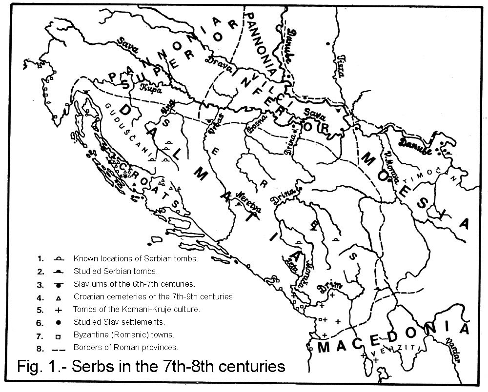 |
Fig. 1.- Serbs in the 7th-8th centuries [click for the large image]1. Known locations of Serbian tombs. 2. Studied Serbian tombs. 3. Slav urns of the 6th-7th centuries. 4. Croatian cemeteries or the 7th-9th centuries. 5. Tombs of the Komani-Kruje culture. 6. Studied Slav settlements. 7. Byzantine (Romanic) towns. 8. Borders of Roman provinces. |
The area beyond these boundaries offers archaeological traces of the South Slavs and other peoples. The graveyards common in the South Slav culture, with the remains of the dead cremated and buried in the ground, have been discovered in the Danube basin (Celarevo, Slankamen)[33] and in the Sava basin (Laktasi, Bijeljina).[34] These findings determine the former northern boundaries of the Serbs. Such graves in the Littoral could possibly belong to the Croats (Kasic,[35] Bakar[36]). Within the boundaries of the medieval Croatia, in the Littoral, archaeologists found numerous skeleton graveyards which undoubtedly belonged to the Croats from the time when they adopted Christianity in the 8th and 9th centuries.[37] These graveyards determine the possible south-western boundaries of the Serbs.
Apart from the Slavs, the population that spoke the Romance languages also lived on this territory. The archaeological findings until the 7th century inclusive give information about the Romanic people or Byzantines living in the hinterland.[38] The Romanic people, known in the written sources, stayed longer in the Littoral - in the towns such as Durazzo, Dubrovnik or Zadar. The town of Svac, about 10 km far from the Coast and Ulcinj, is very significant.[39] The crypts in which the dead were buried in the Christian tradition were discovered in this town. Byzantine jewellery, dishes, and other objects known in the Byzantine regions extending from Crimea, across Sicily, to Istria were found lying by the skeletons. The objects of the Slav origin, such as pots made on a slow wheel and decorated with a comb, were also found. Similar graveyards were also discovered in Durazzo.[40]
These Byzantine graveyards are particularly important for establishing the origin of the Koman-Kruje culture. This culture appeared at the end of the 7th century and disappeared in the 9th. Albanian scientists are trying to use this culture in order to prove the continuity between the old Romanized population and the Albanians of today.[41] However, these skeleton graveyards conceal the remains of special costumes and presents. Unique buckles, shackles known with some nomads, axes as weapons, and imported Byzantine jewellery were found. These findings differentiate this population from the Romanic people of Svac and Durazzo, where there are no such objects. Since the graveyards in the Koman-Kruje culture are situated in the mountains, one should have in mind cattle breeders here. They lived in the area from Mount Rumija to Ohrid Lake. Everything points to the fact that the bearers of the Koman-Kruje culture arrived there at the end of the 7th century.[42] They were probably settled in the region in order to defend the Durazzo-Salonica road, and they were destroyed when the Bulgarians started spreading in the hinterland of Durazzo in the 9th century.
Archaeological findings of the South Slav, Romanic, and Croatian tribes as well as of the Koman-Kruje culture delineate the ethnic area of the Serbs. It is necessary to point out that all the archaeological data on the Serbs coincide with those of their neighbours.
The history of the Serbs in the 9th and 10th centuries is much better known thanks to the work of Emperor Constantine VII. He was rather precise in delineating the boundaries of the Serbian lands in the Littoral. According to him the Serbs lived in Duklja, Travunia and Konavle, Zahumlje, Pagania, and Serbia. The first to come across in the south-east was Duklja in the hinterland of Durazzo, Ljes, Bar, Kotor, and Ulcinj. In the north-west, Pagania was the last Serbian land in the Littoral which bordered on Croatia on the Cetina river. Zahumlje also bordered on Croatia "towards the north". Duklja, Travunia, and Zahumlje bordered on Serbia by the mountains in the hinterland. Serbia "...borders on Croatia in the north and on Bulgaria in the south...," i.e. it reaches to the Croats on the Sava river in the north-west and to Bulgaria on the Vardar river in the south-east. The boundaries of the coastal Croatia were clearly defined, from the Cetina river to the town of Labin in Istria, with the borders on Serbia "...towards the Cetina river and the town of Liven."
Of the eight towns in the principality of Serbia mentioned by Constantine VII the location of almost none of them has yet been clearly defined. If we presume that the towns were listed in some specific order, their locations could be more or less defined based on our knowledge of the locations of the ones already found. The reliable data show that the first of the listed towns Destinik was in Metohia.[43] The next two towns, Cernavusk and Medjurecje were probably situated somewhere to the west of Metohia. The following Dresneik could be Dreznik, the town near the Una river. Between Dresneik and the town of Salines (undoubtedly Tuzla of today, the former Soli) was Lesnik of unknown location. The last two towns, listed in Bosnia, but in the principality of Serbia, were Kotor and Desnik. One of them was near Sarajevo, in the area of Rogacici[44] or Ilidza[45] where some church remains of the period were discovered. The other could be by Desetnik near the town of Kakanj.
The boundaries of Croatia are important for the delineation of the western boundaries of the Serbs.[46] When Serbian Prince Czaslav died around 950, Croatia expanded to the banovina (administrative unit) of Krbava, Lika and Gacko.[47] The data explaining the concept of this administrative unit are found in the Annals of the Frankish Kingdom although the Croats are not mentioned. Prince Borna (around 818-821) is mentioned as the prince of the Guduscani, the people that undoubtedly lived in the region of present-day Lika, i.e. between the Croatia in the Littoral and the Croatia on the Sava river.[48] A little later, it is described how Prince Ljudevit's rebellion against the Prankish authorities was crushed. In 822, Ljudevit fled from Sisak and found shelter with one of the Serbian zhupans. He killed his host and tried to take over his state but had to flee towards the sea where he was murdered. As mentioned earlier, given the route which Prince Ljudevit had to take and the data on the state and the town of Srb in the 14th century, it seems that he must have found shelter in today's Srb near the headwaters of the Una river. Accordingly, in the 9th and 10th centuries, in the farthest west, Serbia bordered on the region of Guduscani in today's Lika, which was included in Croatia later on.
The area of the northern Croatia in the continental part has not been conclusively established. That is why it is more difficult to define the northern boundaries of the Serbs. The boundaries of Zagreb bishopric, constituted at the end of the 11th century, show where the northern boundary of Serbia might have been. It is common in Hungary that the territories of bishoprics coincide with the boundaries of administrative regions. This means that the boundaries of the new bishopric were set around the territory of the old principality with the seat in Zagreb. Thus, the southern boundary of Zagreb bishopric, i.e. of the older principality on the Sava river, extended in the direction Zrinska Gora - Bela Krajina.[49] So, in the 9th and 10th centuries, the Serbs could reach the mesopotamia between the Una and Krka rivers with today's Banija and Kordun (the regions favourable for cattle breeding). Given the structure of the soil, the Serbs could spread over the mountains in the direction of Ogulin.
In the 9th century, Prince Kocelj (861-876) ruled the Lower Pannonia - Vukovo, Srem, Macva. The name of the today's village of Koceljeva in Macva confirms that Serbia bordered on Pannonia. Pope John VIII (872-882) wrote to the Serbian Prince Mutimir (around 850-891/2) to subjugate his bishopric to the Pannonian archbishopric of Saint Methodius.[50] This is just an additional proof that in the north Serbia bordered directly on the regions ruled by Prince Kocelj. Scarce data on the Hungarian inroads into our lands at the beginning of the 10th century cited that Zagreb, Pozega, and Vukovo were looted while neither the Serbs nor Croats were mentioned.[51] This proves that these towns were probably the seats of several principalities of the Croats, Vilci (Wolves), and of the third tribe of an unknown name. At the time of Prince Czaslav (927/928-around 950), the boundary of Serbia could reach the Drava and Danube rivers.[52]
In the north-east and east, the border shifted due to the clashes with Bulgaria. In the mid 10th century, the Morava principality was situated somewhere in the region of Sumadija, the Morava river basin and Branicevo.[53] Based on the location of this principality, the north-east boundary of Serbia coincided approximately with the boundary of Roman Dalmatia - from Mount Cer to Mount Rudnik. Then the border ran southward, between the Zapadna /Western/ and Juzna /Southern/ Morava river basins. It is now difficult to define where exactly the southern boundary was, but it should be somewhere on the watershed of the Morava and Vardar rivers, and on the watershed of the Vardar and Drim rivers.
 |
Fig. 2. Serbs in the middle of the 10th century [click for the large image] |
The archaeological data on the Serbs in the 9th and 10th centuries are too scarce to be used for defining their ethnic area. If compared to the neighbouring countries, known for their numerous sometimes lavish findings, one could get a completely wrong idea about the Serbia of the period. Capital cities, towns, and the seats of bishoprics have not been explored in the Serbian region. Some examples, however, show that this could be a wrong conclusion. The Church of SS Peter and Paul in Ras is the only original bishopric church of the Slavs which is still more or less unchanged. This is a rare example of at least one thousand years long tradition and continuity.[54][55] Another clear proof is the preserved portion of the potter's inscription in Glagolitic about the volume of the jug from Cecan, Kosovo.[56] This not only speaks of the widespread literacy, but also of the stage of development of the state in which the units of measurement were used and the taxes were fixed. At present, we can only speculate about the significant role which Serbia played in the world of the Slavs.
Archaeology cannot shed more light on the period of the 11th and 12th centuries, either. Although the foreign relations changed, the Serbian state was still powerful and more or less of the same size. During the rule of King Mihailo (around 1055-1082) and Constantine Bodin (around 1082-1101), Serbia was a serious adversary of the neighbouring countries. It is worth mentioning the Crusaders' journey under Raymond of Toulouse in the winter of 1096/1097. They travelled for almost 40 days through "Slavonia" (Sclavonia), from the western border to Scutari where they were met by King Bodin.[57] Considering the length of the journey, they probably entered Serbia somewhere in Lika, the westernmost region of Serbia.
In the south-east, the Serbs lived in Kosovo and their southern boundary was somewhere on the Drim river near Mount Debar.[58] In the neighbourhood, somewhere in the region of Elbasan and Tirana, the "Arbani" (Albanians) were being mentioned from the middle of the 11th century.[59]
The schism of the Church and the appearance of Bogumilism had a rather negative impact on the Serbs. Under the pressure of the Hungarians and Rome, in the crusades, the north-west parts of Serbia were taken from it. Later, these parts united under the name of Bosnia. Throughout many centuries, there were constant attempts to convert the Serbian and other Slav population to Catholicism and to include them into a nameless Slav corpus in the Hungarian state. However, a continuous mentioning of the "schismatics" in the mesopotamia between the Sava and Drava rivers, and in Vojvodina show that the Slavonic, i.e. the Orthodox Christian Church service had remained uninterrupted until the Turks came.[60] In the 14th and 15th centuries, the Orthodox Slavs in Hungary could not be differentiated from the Serbs, either because the Serbs had lived there before or because they were assimilated.
The territorial ratio of the Orthodox Church to the Catholic Church is evident in the distribution of the epigraphs. Until the 13th century, Cyrillic monuments spread to the island of Brac and the Cetina river in the west, and in the hinterland they reached the original Bosnia.[61] Later on, in the 14th and 15th centuries, epigraphs became more numerous, and very common on tombstones. They were recorded west of the line: Mljet (island) - Peljesac (peninsula) - Gradacac - Pakrac (towns).[62] A considerable number of Latin epigraphic monuments were also discovered, especially in the Littoral. However, the Slav population could be differentiated by them only in some rare cases. After 1248, when Rome once again allowed the use of the Glagolitic alphabet, many Glagolitic inscriptions appeared.[63] The arrangement of these inscriptions coincided with the spreading of the Cyrillic alphabet in the west. Insignificant overlaps show that there were no significant shifting of the Serbs towards the west. Thus the western boundary of the Serbian ethnic area was determined in the late Middle Ages.
 |
Fig. 3.- Distribution of the medieval epigraphic monuments [click for the large image] |
The original ethnic area of the Serbs kept its cultural homogenity although they were divided in ten or so small states from the end of the 14th century. The best examples of the above are the tombstones. These tombstones are massive and usually in the form of different casks. Some of them are ornamented either with small figures, symbolic drawings or some other ornaments. The Serbian art is well known and has attracted much attention ever since. For long, propaganda has presented these tombstones as a form of the Bogumil art, which was wrong.[64] Inscriptions on the tombstones are all in Cyrillic.
Graveyards with tombstones were situated in the same area where the old pagan graveyards with burial mounds were. This means that the settlements probably were nearby, and that the old cattle breeders' way of life was preserved. With the spreading of the Serbian cattle breeders towards the west (the Vlachs) the use of the tombstones increased and there were many of them in Dalmatia and in the Krajina, from the Cetina river to Lika and Pakrac.
Graveyards with tombstones are located by the churches, both the destroyed ones and those still in existence where people are being buried.[65] As a rule, these churches face east, the Orthodox churches, as the tombstones themselves. Very rarely these churches and contemporary graveyards with tombstones are Catholic. When it is possible to determine the original appearance of the present-day Catholic church it becomes obvious that these churches are the remodelled ones. For example, St. George's Church in Cavtat, surrounded by broken tombstones, has a flat wall on the east side. But in the altar, a semicircular apse can be seen in the floor. In Mokro Polje, by Zavodje near Knin, in a preserved graveyard with tombstones, there are church ruins with semicircular apse. The apse passes into a flat wall towards east, as in Cavtat. This allows a supposition that all the churches located in the graveyards with tombstones used to be Orthodox churches.
At the locations of the tombstones, pottery from the same period was collected during archaeological excavations. This is the pottery characteristic of the Serbian Dinaric region, unpolished, made on a slow wheel. The pottery is represented mostly by cooking pots with long open brim, without ornaments or variegated with wavelike impressions, stripes and small pits. At the bottom they could have a seal print from the wheel. They were found in the fortified towns westward of the Drina river[66] and in the explored monasteries in the region of the Despotovina.[67] They date back to the time of the Turkish inroads - the late 14th and 15th centuries. Such pottery is the characteristic of the original Serbian ethnic area preserved until the present. The locations of the workshops with slow wheels in the 20th century coincide with the locations where the pots of the same make were found in the 14th and 15th centuries; even the appearance or the pots was the same.[68][69]
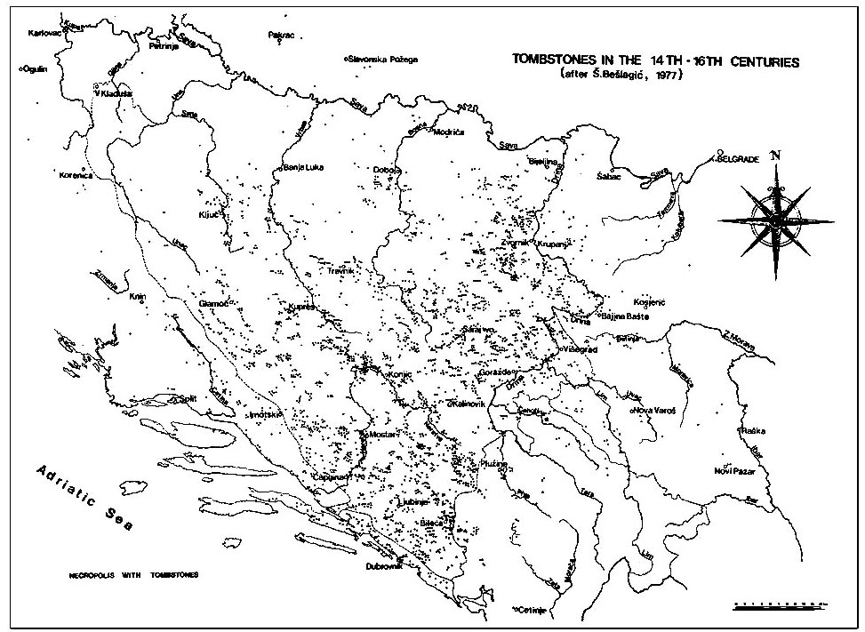 |
Fig. 4. - Tombstones in the 14th-16th centuries [click for the large image] |
During the 13th and 14th centuries, the Serbian ethnic area in the east was formed. After the fall of the Byzantine Empire in 1204, the Nemanyich shifted the borders of Serbia towards the east and south. Ac the time of Emperor Stephen Dushan, the eastern border ran from Djerdap to the Struma river valley, and it reached the Gulf of Corinth in the south. These events and the borders are well-known thanks to the written historical data. The cultural monuments of the Serbs and other Slavs in the liberated and annexed regions somewhat differed due to the Byzantine influence. Still, although many churches have been preserved, there are not very many archaeological data related to the Vardar and Struma river basins.
The region which pretty much coincided with the idea of today's central Serbia was formed at the time of Prince Lazar (1371-1389). Although constantly threatened by the Turks, the Serbs developed material and spiritual culture under the strong influence of theologians, artists, and craftsmen from Constantinople and Thessaloniki. Cultural and industrial peak was reached at the time of the Despotovina. In the sense of archaeology, apart from unique churches and towns, the Serbian Despotovina was known for its jewellery and especially for the pottery. Glazed bowls, dishes, plates, jugs, and flasks bear specific ornaments impressed in "zgraphito" technique. Cooking pots were mostly made on a fast wheel. They had long open brims and were ornamented alternately with ribs with small pits and an engraved ornament.
The pottery of the Serbian Despotovina is also known in the region of Kljuc and the Negotin Krajina.[70] After Turkey had annexed Vidin in 1396, these regions became a part of Serbia and remained within the Serbian boundaries until the fall of the Despotovina under the Turkish rule in 1459. Although there are no specific historical data,[71] this is confirmed by the existence of the pottery. The distribution of the findings of this special pottery makes it possible for archaeologists to follow the movements of the Serbs caused by the Muslim invasion. In southern Hungary (today's Vojvodina, the mesopotamia between the Sava and Drava rivers, Baranja), among the pieces of pottery of central European style, it is easy to discern the rougher Serbian pottery pieces dating back to the 14th and 15th centuries, as well as the pieces of the Byzantine style.[72]
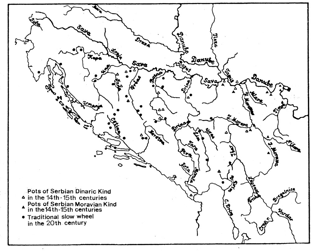 |
Fig. 5. - Distribution of the late medieval Serbian pottery [click for the large image] |
This survey based on the available archaeological data has pointed to the undoubted continuity on the Serbian ethnic area. This is the area that has not undergone any considerable changes since the 7th century. Certain spreading of the Serbian people is understandable since the Serbs have always been the most numerous Slav people in the Balkans.
Footnotes
- Constantine Porphyrogenitus, De administrando Imperio, ed. Gy. Moravcsik, English translation by R. J. H. Jenkins (Budapest, 1949).
- Milica and Djordje Jankovic, Sloveni u jugoslovenskom Podunavlju /The Slavs in the Yugoslav Danube Basin/ (Belgrade: Muzej grada Beograda, 1990), pp. 20,25.
- Georgiy A. Haburgaev, Etnonimiya "Povesti vremennih let" (Moscow: Izdatelstvo Moskovskogo universiteta, 1979). pp.210-212.
- Povest vremennih let (Moscow, Leningrad: Akademiya nauk SSSR, 1990), pp.11, 207.
- Heinrich Gelzer, Ungedruckte und ungenugend veroffentlichte Texte der Notitiae episcopatuum (Munich, 1901), pp. 538-545.
- Jovanka Kalic, "Naziv Raska u starijoj srpskoj istoriji (IX-XII vek)," /Name Rashka in the Early Serbian History (9th-12th centuries)/ in Zbornik Filozofskog fakulteta, XIV-1 (Belgrade, 1979), pp. 79-91.
- Sima Cirkovic, Istorija srpskog naroda /History of the Serbian People/ (Belgrade: SKZ, 1982) II, p.376
- Anne Comnene, Alexiade (Regne de L'Empereur Alexis I Comnene 1081-1118) II, pp. l57:3-l6; 1.66: 25-169. Texte etabli er traduit par B. Leib t. I-III (Paris, 1937-1945).
- Nada Klaic, Povijest Hrvata u ranom srednjem vijeku /History of the Croats in the early Middle Ages/ (Zagreb: Skolska knjiga, 1975), p. 211.
- Raimundi de Aguilers canonici Podiensis Historia Francorum qui ceperunt Iherusalem, Recueil des historiens des croisades (Paris, 1866), p. 237.
- Viaggio in Dalmazia dell'abate Alberto Fortis (Venezia, 1774), 1, 2.
- Zeljko Skalamera and Marko Popovic, "Novi podaci sa plana Beograda iz 1683." /New Data from the Map of Belgrade of 1683/ in Godisnjak pada Beograda, XXIII (Belgrade, 1976), pp. 40-42.
- Nada Klaic, Povijest Hrvata u razvijenom srednjem vijeku /History of the Croats.../ (Zagreb: Skolska knjiga, 1976), pp. 600, 607-610.
- Constantine Porphyrogenitus, Cap. 30.
- A. Meineke ed. Ioannis Cinnami epitome rerum ab Ioanne et Alexio Comnenis gestarum (Bonnae, 1836), pp. 102:18, 103:19.
- Willermi Tyrensis archiepiscopi, Historia rerum in partibus transmarinis gestarum, Recueil des historiens des croisades, I (Paris, 1884), XX, 4:946, 947.
- Jovan Cvijic, Balkansko poluostrvo i jugoslovenske zemlje /Balkan Peninsula and South Slav Countries/ (Belgrade: Drzavna stamparija Kraljevine Srba, Hrvata i Slovenaca, 1922), pp. 279-286.
- Vidukind Korveyskiy, Deyanija Saksov, ed. G. E. Santchuk (Moscow: "Nauka", 1975), p. 257.
- Herausgegeben von Joachim Herrmann: Die Slawen in Deutscliland (Berlin: Akademie-Verlag, 1'985).
- Irma Cremosnik, "Istrazivanja u Musicima i Zabljaku i prvi nalaz najstarijih slovenskih naselja kod nas," /Research in Musici and Zabljak and the first Findings of the earliest Slav Settlements/ in Glasnik zemaljskog muzeja, XXV (Sarajevo, 1970), pp. 45-111.
- Georgije Ostrogorski, Istorija Vizantije /History of Byzantium/ (Belgrade: Prosveta, 1959), pp. 99-121.
- Zhivka Vzharove: Slavyanski y slavyanoblgarski selishcha v Blgarskite zemi od kray na VI-XI vek (Sofia: Blgarska akademiya na naukite, arheologicheski institut i muzey, 1965); Slavyani i Prablgari po danni nekropolite ot VI-XI v (Sofia: Blgarska akademiya na naukite, arheologicheski institut i muzey, 1976).
- Jankovic and Jankovic, Sloveni....
- Jankovic and Jankovic, "Rekognosciranje...," /Reconnaissance.../ in Arheoloski pregled. 20 (Belgrade, 1978), p. 188.
- Cremosnik, "Ranoslovensko naselje...," /Early Slav Settlement.../ in Godisnjak ANUBiH, 15 (Sarajevo, 1977), pp. 227-305.
- Povest vremennih let, pp. 15. 211.
- Die Slawen in Deutschland, pp.30-31, Fig. 10.
- Jankovic and Jankovic, Sloveni..., pp.20, 25.
- Pavao Andjelic, "Dva srednjevekovna nalaza iz Sultica kod Konjica," /"Two Medieval Findings at Sultic near Konjic"/ in Glasnik Zemaljskog muzeja, XIV (Sarajevo, 1959), pp. 203-214.
- Vasile Boroneant and Ion Stinga, "Cercetarile privind secolul al XII-lea de la Ostrovul Mare," in Drobeta (Turnu Severin: Muzeul regiunii Portilor de fer, 1978), pp. 87-107.
- Povest vremennih let, pp. 15, 211.
- Aleksandar V. Solovjev, "Dva priloga proucavanju Dusanove drzave," /Studies of Emperor Dushan's state.../ in Glasnik Skopskog naucnog drustva, II (Skoplje, 1927), pp. 26, 30.
- Jankovic and Jankovic, Sloveni..., pp. 90, 104-105, 117.
- Zdenko Zeravica, "Ranoslovenska nekropola Bagrusa u Petosevcima kod Laktasa," /An Early Slav Necropolis.../ in Glasnik Zemaljskog Muzeja, 40-41 (A) (Sarajevo, 1985-1986), pp. 153-154.
- Janko Belosevic, Materijalna kultura Hrvata od VII do IX stoljeca /Material Culture of the Croats from the 7th to the 9th century/ (Zagreb: Liber, 1980), pp. 46-48.
- Zdenko Vinski, "Gibt es fruhslawische Keramik aus der Zeit der sudslawischen Laudnahme?" in Archaeologia Jugoslavica, I (Belgrade, 1954), pp. 71-73.
- Belosevic, op.ch., pp. 67-72.
- Jankovic and Jankovic, Sloveni..., pp. 19-20.
- Emina Zecevic, "Rezultati istrazivanja srednjevekovnog Svaca," /Research Results of the Medieval Svac/ in Glasnik Srpskog arheoloskog drustva, 5 (Belgrade, 1989), pp. 112-114.
- Patos Tartari, "Nje varreze e mesjetes se hershme ne Durres," in Iliria, 1 (Tirana, 1984), pp. 227-244.
- Vladislav Popovic, "Albanija u kasnoj antici," /Albania in the late Classical Period/ in Iliri i Albanci (Belgrade: SANU, 1988), pp.201 -250.
- Joachim Werner, "Neue Aspekte zum Awarischen Shatzfund von Vrap," in Iliria, 1 (Tirana, 1983), pp. 191-201.
- Relja Novakovic, Gde se nalazila Srbija od VII do X veka /Where Serbia was situated from the 7th to 10th centuries/ (Belgrade: Narodna knjiga, 1981), pp. 61-63.
- Cremosnik, Izvestaj...," /Report.../ in Glasnik Zemaljskog Muzeja, VIII, 302-315.
- Tihomir Glavas, "Iskopavanje preromanicke crkve u Vrutcima kod Vrela Bosne," /Excavations of a pre-Romanic Church in Vrutci near Vrelo Bosne/ in Glasnik Zemaljskog muzeja, 37(A), 1982, pp. 93-122.
- Klaic, Povijest Hrvata u ranom srednjem vijeku, Appendix IX.
- Novakovic, op. cit., pp.41-48.
- Einhardi Annales, Annales Regum Franconim, Pertz, Monumenta Germaniae I. See An. 822.
- Klaic, Povijest Hrvata u ranom srednjem vijeku, pp. 497- 507.
- Ljubomir Maksimovic, "O vremenu pohoda bugarskog kneza Borisa na Srbiju," /Prince Boris Campaign on Serbia/ in Zbornik filozofskog fakulteta, 14-1 (Belgrade, 1979), p.73.
- Chronicon Anonymi regis notarii, Gesta Hungarorum, Scriptores rerum Hungaricum I (Budapestini, 1937), pp. 87- 88.
- Ljetopis popa Dukljanina (Zagreb: Matica hrvatska, 1950), pp. 64-66.
- Constantini Porphyrogeniti, De cerimoniis aulae byzantinae, ed. I. Reiskins (Bonnae, 1829), pp. 691:8-13.
- Radoslav Mihailovic, "Crkva Svetog Petra kod Novog Pazara," /St. Peter's Church near Novi Pazar/ in Novopazarski Zbornik, 10 (Novi Pazar, 1986), pp. 67-100.
- J. Neskovic and R. Nikolic, Petrova crkva kod Novog Pazara. /St. Peter's Church near Novi Pazar/ (Belgrade: Republicki zavod za zastitu spomenika kulture, 1987).
- Gordana Tomovic, "Glagoljski natpis sa Cecana" /Glagolitic Inscription from Cecan/, in Istorijski casopis, XXXVII (Belgrade, 1990/1991), pp. 5-18.
- Raimundi de Aguilers..., p. 237.
- Comnene, Alexiade, III, 84:11-23.
- B. Ferjancic, "Albanci u vizantijskim izvorima" /The Albanians in Byzantine Sources/ in Iliri i Albanci (Belgrade: SANU, 1 988), pp. 285-302.
- Dragoljub Dragojlovic, "Sizmaticki popovi franjevackih Dubia i pravoslavna tradicija u Srednjevekovnoj Bosni," /Schismatic Priests of Franciscan Dubia and Orthodox Tradition in Medieval Bosnia/ in Balcanica annuaire de l'institut des etudes Balkaniques, XVI-XVII (Belgrade, 1985-1986), pp. 43-54.
- Rade Mihaljcic, "Nementragende Steinischriften in Jugoslawien vom Ende des 7. bis zug Mathe des 13. Jahrhunderts" in Glossar zur fruhmittelalterlichen Geschihte im Ostlichen Europa, 2 (Wiesbaden: Franz Steiner Verlag GmbH, 1982).
- Sefik Beslagic, Stecci, tipolosko-kataloski pregled /Tombstones.../ (Sarajevo: Veselin Maslesa, 1977), map 1.1.
- B. Fucic, Glagoljski natpisi /Glagolitic Inscriptions/ (Zagreb: JAZU, 1982), Figs. 2-4.
- Beslagic, Stecci - kultura i umetnost /Tombstones - Culture and Art/ (Sarajevo: Veselin Maslesa, 1982), pp. 485- 513.
- Ljubo Sparavalo, "Srednjevjekovna groblja, crkvine i crkve na podrucju Sume trebinjske," /Medieval Cemeteries, Chapels and Churches.../ in Trubunia, 5 (Trebinje, 1979), pp. 53-136.
- Andjelic, Bobovac i Kraljeva Sutijeska (Sarajevo, 1973), pp. 111-112, 181-182.
- Emilija Pejovic, "Katalog arheoloskih nalaza" /The Catalogue of Archaeological Findings/ in Blago manastira Studenice (Beograd: SANU, 1988), p.73.
- Cvetko Popovic, "Tehnika primitivnog loncarstva u Jugoslaviji," /Primitive Pottery Techniques in Yugoslavia/ in Glasnik Zemaljskog muzeja, XIV (Sarajevo, 1959), pp. 25- 57.
- Persida Tomic, Grncarstvo u Srbiji /Pottery in Serbia/ (Belgrade: Etnografski muzej, 1983), pp. 24-32.
- Djordje Jankovic,"The Medieval Pottery of the Serbian Lower Danube Basin," in Balcanoslavica, 3 (Belgrade. 1974), pp. 108-119.
- Dusanka Bojanic-Lukac, "Krajina u vreme turske vladavine," /Krajina during Turkish Rule/ in Glasnik Etnografskog muzeja, 31-32 (Belgrade, 1968-1969), pp. 65-68.
- Marko Vuksan, "Kovin, lokalitet Grad - sondazno istrazivanje 1986. godine," in Glasnik Srpskog arheoloskog drustva, 5 (Belgrade, 1989), pp. 117-122.
Dr Djordje Jankovic
Assistant Professor in the Department of Archaeology, Faculty of Philosophy, University of Belgrade. He teaches Medieval Archaeology from the 4th to the 17th centuries. He has published about twenty scientific papers in medieval archaeology, in particular within the area of Slav Archaeology.
Books
- Podunavski deo oblasti akvisa u VI i pocetkom VII veka /The Danube Basin Section of the Province of Akvis in the 6th and at the beginning of the 7th century/ (1981)
- Sloveni u jugoslovenskom Podunavlju /The Slavs in the Yugoslav Section of the Danube Basin (1990, Co-author with M. Jankovic)
- Srpske gromile /Serbian Tumuls/ (1998).